The Path to Pointe-aux-Vieux

Video

A flashback to the Archaeological landscape in 2011 at the Acadian homestead site, Pointe-aux-Vieux (1728-1758).
Field crew, volunteers and visitors, from near and far, all followed this path to arrive at the Provincially designated archaeological site and stunning vista at Low Point, Prince Edward Island.

A Brazen Love for The Brae(s)

Gallery

This gallery contains 2 photos.

My mind often wanders to a little white-washed stone house on a winding road. Its bright red door perpetually welcomes me home. I sit with a good book beside a roaring peat fire drinking tea. The house is in a … Continue reading

Rate this:

Scratching the Itch on the Cardigan River

One of the very few problems with doing archaeological work on Prince Edward Island is that for a good 5-6 months of the year, you have to spend it indoors thanks to this terrible thing called Winter.  In Canada, it’s a time when snow flies and temperatures plummet (to people living in equatorial or sub-equatorial locales:  Yeah, I know, you guys have this season as well.  But this is the real Winter, so spare me your horror stories of “frigid” 20-degree Celsius days/nights).  Of course, Santa Claus pays a visit during this time, but that’s about the only positive thing I can think of.  Anyhow, let’s get this thing back on topic.

I suppose in a way it’s probably good for us to have to spend some time inside, or else we’d never get anything done in the way of post-excavation processing, research, and report writing.  But when you turn that corner in April and things begin to warm up a bit, you get this itch, a really annoying one, and the only way to scratch it is to hit the field.  This year, we scratched that itch with time spent down at the river – the Cardigan River, to be precise.

For those of you unfamiliar with the geography of Prince Edward Island, the Cardigan River is one of three major (Canadian heritage) waterways that form the Three Rivers, along with the Montague and Brudenell rivers.  These tidal estuaries have played a significant role in the history of eastern Prince Edward Island, beginning with the first Aboriginal peoples thousands of years ago and continuing into today.

Satellite image of Prince Edward Island with the Three Rivers system circled.

Satellite image of Prince Edward Island with the Three Rivers system circled.

Close(r)-up view of the Three Rivers.

Close(r)-up view of the Three Rivers.

Because of the importance of these rivers to Island history, we decided that it might not be a bad idea to begin a systematic survey to assess their archaeological potential.  Given the size of the rivers, however, a project like this is a massive undertaking, which we knew.  But if there’s one thing we’re used to, it’s big projects (*cough* PAV *cough*).

Remember that itch I was talking about?  Well, we had it real bad back in April.  It was so bad, in fact, that on April 23 we threw caution to a brisk northeasterly wind and hit the open road for Georgetown, 10-degree Celsius reading on the thermostat be damned.  The sun was shining as we sped along the Trans Canada in our red Dodge Caravan rental, and morale was surging.  All hail being in the field!

Anyway, we had decided on a jumping-off point at the end of the Earl Power Road, on the left just before you enter Georgetown proper.  I’ll admit, it may seem like an arbitrary place to begin a survey; however, we had been tipped off to an arrowhead having been found in the vicinity, and so we thought that that would be a good place to kick things off. After a quick bite to eat, the six of us (Dr. Helen Kristmanson, Meghan Ferris, Dawne Knockwood, Smantha MacKinnon, Alicia Compton , and myself) piled out of the van, artefact bags in hand, and made our way down to the shore.  We headed ENE towards the mouth of the river and straight into a relentless wind that chilled us to the core for the nearly three hours that we surveyed.  I won’t lie, it was rather brutal, and I’ll admit my snotsicles were pretty atrocious by the end. (FYI, “snotsicles” are “snot icicles”, an unfortunate reality of the cold Canadian climate.)  Anyway, here’s a Google Earth snapshot of our travels:

Our travels on April 23.  The arrows indicate direction, obviously.  I did them up in Paint, which is why they look so childish.

Our travels on April 23. The arrows indicate direction, obviously. I did them up in Paint, which is why they look so childish.

As you can see, we started out by walking the beach along the bank, and didn’t go all that far before turning back and investigating that largish spit of land you see above, essentially a big, flat sand dune.  Along the way, we encountered quite a bit of recent detritus, but also found numerous historic artefacts such as ceramic sherds, glass, and the odd chunk of metal here and there, probably associated with these residents shown in Meacham’s 1880 Atlas of Prince Edward Island:

Capture

Unfortunately, nothing Aboriginal was found, despite our insider information.

Entirely frozen, we finished off the day by putting in at the nearest Tim Hortons (coffee shop) in Montague in an attempt to stave off hypothermia, and decided to take stock of our artefacts and write up some field notes.  We drew quite a few furtive and sideways glances, so something tells me that people in deep discussion with Ziploc bags full of odds and ends spread out over two tables and poring over maps and aerial photos isn’t a very common sight at that establishment.

Well, that was the first day in the field for 2013, and also the first day of our survey of the Three Rivers.  Despite good intentions, we were unable to continue with that particular survey work because of other commitments, but it is definitely a project that we will be resuming in the future…hopefully when it’s warmer.

And now for a photo recap.

See you in the next post!

Off-site Outreach

As most of you are already aware, last year marked our first field season in which we managed to incorporate a public archaeology experience. While in the past we had the occasional volunteer or two at our Pointe-aux-Vieux site, 2012 at Orwell Corner represented the first time our work became uber-accessible to one and all, a fact on which we capitalized (as did the general public!); however, it was not the first time we attempted to reach out and bring Prince Edward Island archaeology to the people of Prince Edward Island (and possibly beyond). You see, while we always like to engage people on-site, every so often we like to take the opportunity to seek them out off-site. To paraphrase that iconic line from Field of Dreams: Present on it, and they will come.

Well, that’s the hope anyway.

While it’s been a busy and somewhat hectic (ongoing) field season in 2013, we’ve managed to carve out more time to present our craft to the public, an activity we typically reserve for the off-season. Below is an account to date of our presentations/workshops. As you’ll see, we’ve spent quite a bit of time working with kids, and I know I don’t need to tell you that it has provided for some interesting experiences.

Prince Edward Island Provincial Heritage Fair 2013

Each May, some of the best and the brightest elementary and junior high school students on PEI gather at the Confederation Center of the Arts in Charlottetown for the Provincial Heritage Fair. What is that, you ask? Well, here’s what the Department of Tourism and Culture has to say on their website:

The Provincial Heritage Fair is a grand celebration of Canada’s heritage, in the form of student history projects. Students in Grades 5 to 9 have an opportunity to explore the history of their families, communities, province and/or country.

Anyway, this year (May 16), as in previous years, we were asked to put on just one of the many heritage-related workshops that are offered to students throughout the day. It was my first time involved with this venture, and I have to say, it was a blast. We presented to about thirty students on the basic theme of “What is Archaeology”. Essentially, we would ask them questions along the lines of “What is an artefact?”, “What is an archaeological site?”, “Why do archaeologists excavate sites?” and so on, allowing them to provide us with their own answers, after which we would then deliver a more professional answer (although to be fair, there were a lot of times when it wasn’t even needed, as kids can be really perceptive). We also included an artefact guessing game, and capped the presentation off with a workshop on how to make Mi’kmaq clay pots, giving them a chance to get their hands dirty. All in all, a tonne of fun, and illuminating for them, and for us as well.

Highlight

(While making clay pots)

Student: “I’m going to go home tonight and tell my mom and dad that I learned how to make pot today!”

Me: “‘A’ pot. You’re going to tell them how you learned to make a pot. The ‘a’ is very important. Please don’t leave it out, or I’m going to get fired.”

Photos

253231_10151375423520686_828259277_n

Isaac Stewart taking students through an archaeology slideshow presentation.

945088_10151375426895686_585999709_n

Believe it or not, this photo actually captures the “learning how to make pot” moment.

599419_10151375427745686_111373573_n

Clay pots in progress.

University of Prince Edward Island Day Camp

On July 11, we participated for the first time in the Panther Academy, a summer day camp program put on by the University of Prince Edward Island. They were looking to do something with archaeology, and when we found out, we eagerly offered our services. We gave the same presentation as the heritage fair, this time to a group of slightly younger students. We weren’t sure how they would take to the material, but they were quite energetic, and relished the question-answer format, which took us a bit by surprise. Because of time constraints, we held off on the clay pot-making portion of the routine, but opened the floor to extended answers on some of our questions. Again, a good time was had by all.

Highlights

1) An elaborate and epic one-sided discussion of evolution by a seven-year-old, from trilobites to dinosaurs to humans.

2) Being taught the many ways in which a shipwreck can be exposed, including – but not limited to – a beaver that dams up a river.

Photos

UPEI DAY CAMP PRESENTATION JULY 11, 2013 DSC06805 (8)

Meghan Ferris (back row, far left) and Isaac Stewart (back row, far right) with day campers at UPEI.

Orwell Corner Historic Village Public Archaeology Presentation

Because we’re currently into our second year at our site in Orwell Corner, we decided that it was time to get a presentation together on the work we’ve been doing and let people in on some of our findings to date. On July 30, we crashed the Community Hall in Orwell, and presented to a not-so-numerous crowd of about eleven people, taking them through our public archaeology program, as well as our research into the material culture and human history of the site. Although it wasn’t the most well attended of presentations, it was still a success, and a great opportunity for us to fine-tune our public speaking skills, as well as refine our presentation, which we hope to give again at some point.

Museum Madness 2013

This past Wednesday (August 21), we hit up the Garden of the Gulf Museum in Montague the Beautiful for Museum Madness 2013. (Fun fact: the Garden of the Gulf is the oldest museum on the Island, established in 1958.)  Back in June, we were approached by staff there about getting involved with an annual summer program called “Museum Madness”, a series of fun and informative weekly activities aimed at exposing children to history.  We used our by now tried and true presentation, taking a group of young kids between ages six and twelve through the basic aspects of archaeology. Afterwards, we took them outside the museum and taught them how to make clay pots – no marijuana jokes this time, thankfully!

Highlight

Watching the transition from intense clay pot-making focus to about a dozen kids taking their clay and mashing it every which way against the brick exterior of the museum in an attempt to make cool impressions.

Photos

MM2013

Isaac Stewart and Meghan Ferris presenting on archaeology, with Dawne Knockwood manning the slides.

MM2013 2

Dawne Knockwood giving a step-by-step workshop on how to make a Mi’kmaq clay pot.

See you in the next post!

The Georgetown (Maybe) Shipwreck – Part One

For all you landlocked landlubbers (check out that alliteration!), one of the realities of living on an island is that you are constantly exposed to tidal action (literally from all sides, because you’re on an island, and that’s kind of how they work). Anyway, if you’re into beachcombing, it is one of your greatest allies, helping to shift the sands and bring things to the surface; however, if you’re into building multi-million dollar homes/cottages perched precariously close to the water…well, let’s just say you better enjoy them while you can, before Mother Nature has her fun.  And if you’re into archaeology like we are, that tidal action is a two-edged sword.  By times, it has proven detrimental to our sites located along the coast (notably in 2010, when three storm surges in as many weeks wiped out about half of our site at Pointe-aux-Vieux); recently though, as Dr. Kristmanson alluded to in her previous post, tidal action worked very much in our favor when it helped to expose the remnants of a ship off of Georgetown.

As Dr. Kristmanson mentioned, there was that whole super-moon thing in June, which resulted in abnormally high tides.  In early July, we received word that a shipwreck had surfaced at the entrance to Georgetown Harbor, and over a two-week period we spent about three days collecting what data we could to learn about the age and type of the vessel.  Because we rarely deal with shipwrecks (even though the entire coastline of Prince Edward Island could accurately be termed a graveyard of ships), we’re more than a little out of our comfort zone on this one, which is why we are currently compiling all of the data into a report.  When completed, this report will be sent to an Atlantic Canadian shipwreck/marine heritage expert we’ve been consulting, who will provide us (hopefully) with a few answers.  So this will be a two-part feature, with the second act being a more detailed discussion of our investigation that we’ll put up on the blog whenever our expert gets back to us with his interpretation – predicated, of course, upon us actually getting the data into a readable format, which has been proving challenging to say the least, especially with our field season in full swing.

Seriously.  This has absolutely nothing to do with us being lazy.

In the meantime, however, we thought it might be nice to tease you guys a little bit (alright, alright, thought it would be a good idea), so attached below are the links to all of the media coverage the shipwreck received.  Final count:  4 written articles, 3 radio segments (I could only track down two), and 1 televised news story.   As Dr. Kristmanson pointed out, the amount of interest in this shipwreck affair was intense.  We’ve never seen anything like it, and to be honest, we’re still scratching our heads a little bit (because we’re confused, not because we have lice).  I mean, the work we do typically (though not always) gets a modicum of coverage simply because it’s archaeology, which is still a relatively new concept/practice on the Island; but for some reason, this particular investigation garnered a tonne of interest.   The only caveat, however, is that you take the oral history you’re about to read/hear with a good pinch of salt.  A really good pinch, even.

Other than that, enjoy, and stay tuned for Part Two, headed your way at some point (but don’t hold your breath, by any means).

Newspaper Articles:

http://www.peicanada.com/eastern_graphic/publication/shipwreck_found_georgetown

http://www.theguardian.pe.ca/News/Local/2013-07-24/article-3326828/Historic-shipwreck-being-unearthed-near-Georgetown/1

http://www.cbc.ca/news/canada/prince-edward-island/story/2013/07/22/pei-georgetown-shipwreck-kristmanson-584.html

http://digitaljournal.com/article/355138

Television Coverage:

http://www.cbc.ca/player/News/Canada/PEI/ID/2397865808/

Radio Segments

http://www.cbc.ca/islandmorning/history/2013/07/22/150-year-old-shipwreck-discovered-near-near-poxy-island/

http://www.cbc.ca/islandmorning/musicperformer/2013/07/25/poxy-island-shipwreck—mike-martell/

P.S. – I’m calling it the “maybe” shipwreck because the possibility exists that it isn’t even a shipwreck in the traditional sense of the word (ie the vessel went down in a storm/disaster at sea).

P.P.S. – And yes, I am aware that I used about the most unimaginative title out there for this post.  So you can either cut me some slack, or walk the plank.

images

Thinking about Public Archaeology


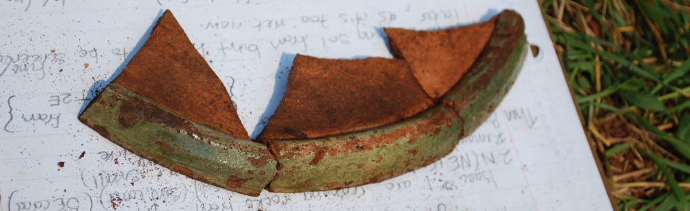
Recently we were called out to investigate a remnant shipwreck that had materialized on the shoreline near Georgetown, Prince Edward Island. The vessel had become visible after a super-moon tidal event had stripped the beach, exposing some articulated framework and timbers (Meghan Ferris and Isaac Stewart are shown below taking detailed measurements). 

Although the wreck’s name is unknown, many locals were aware that for decades it had quietly shimmered in and out of view and it wasn’t long before a few stories began to surface. Some identified it as a 19th century vessel delivering small pox victims to a quarantine station on nearby Poxy Island; others suggested it was a vessel delivering potatoes to Newfoundland in the mid 20th century.  In fact, the only common thread was a mutual childhood memory of playing on a wreck of varying descriptions – depending on the age and recall power of the narrator.

clip_image002

In spite of the odds against finding the vessel’s identity, the public imagination was ignited by the drama and intrigue associated with a wrecked ship and the tantalizing notion of treasure lurking amidst the ruins.  The media followed us closely as we took measurements and photographs, ever conscious of the hovering gaze of history buffs and would-be fortune hunters alike.  As for us, we were delighted and slightly surprised at the surge of interest.  While we, too, were excited by the chance to investigate a shipwreck, for us it presented a unique archaeological site that required systematic documentation in order to collect every bit of information we could, knowing that the site could disappear again at any time. 

Our research and consultation with a marine heritage expert, however, soon led us to consider the strong possibility that the site may not even be a wreck!  Given the angle at which the ship’s bow is positioned in relation to the strand line, it is likely that the vessel was either hauled ashore at the end of a useful life, or hastily manoeuvred onto the beach while in a situation of distress.  In either case, anything of value, including the vessel itself, would have been sold off in bits and parts leaving little for the curiosity seekers and treasure hunters.

clip_image004

Everywhere in the world people are fascinated by the idea of archaeological “treasure” and even though archaeological sites are protected by law, portions of the vessel (of no commercial value) began to disappear between our visits. Often, when armchair interest escalates to spade wielding (or the use of other exploratory devices) archaeologists and treasure hunters enter into highly charged territory.  We had no such experience at Georgetown. We were delivered to the site each day by Steve McLean and his family, the people who brought the site to our attention in the first place and gave generously of their time and personal resources to assist in our work.

While these competing viewpoints will always exist to some extent, most archaeologists recognize the value of sharing with our local communities just why archaeological sites mean what they do to us and why legislation is in place to ensure that trained professionals attend to their investigation, preservation, and designation. Is public archaeology one way to bridge the divide? And what exactly is public archaeology? I am no expert on the subject; this blog entry is a simple expression of my views, which have oscillated between unsure and supportive. Here’s why:

A little more than four years ago, during excavations at Pointe-aux-Vieux, an 18th century Acadian site in western PEI (below), we were visited by a bespectacled and boisterous figure whose energy bounced off everything in sight.  (In fact, his energy was matched only by that of the mosquitoes that greeted us with ferocious punctuality each morning to return every afternoon for fly-high-tea. Note that I’m not comparing him to an insect, just his energy level, which I admire – the insects, on the other hand, could afford to relax their regimen).

During this visit, I noticed how our guest’s merry chatter was diverted each time he caught a better and closer view of the field-crew at work.  With a mixture of joviality and disbelief, and without a trace of malice, he expressed his incredulity – in fortissimo – with zinging clarity and a distinct echo.  His brewing verdict was registering loud and clear: these people are barmy!  By this point, the folks at Lennox Island were probably lined up on shore with high powered binoculars trained on the site as the voice of Claude rang out across Malpeque Bay.

clip_image006

Before long, as you may have predicted, our visiting skeptic gradually yielded to the curiosity that lured him back to the site again and again albeit as a confirmed Observer, if not yet Believer.  Invitations to join us in our excavation units were met initially with hand-waving protest.  But as he watched us trowel the soil, exposing objects last touched almost 300 years ago by his own ancestors – or at least their neighbours– curiosity replaced doubt and restless interest led to some pit-side grumbling (I want to do more than just watch!).  An intellectual and emotional transformation was underway.

Next thing we knew our doubting hero was participant extraordinaire.  Claude Arsenault: Man about Birch Hill, Artist, History Buff, Aficionado of the Chinese Shar-Pei, Burgeoning Genealogist … Doubter… trowel in hand, dirt on knees, eyes alive with wonder, was hooked 

clip_image008

Claude (pictured above) is the first to recount the story of his ‘conversion’ (much better than I ever could) and we have laughed with him many times about his inaugural visit – in fact he brings laughter to all of our times together. He has become a good friend to us all and is well appreciated as a clever, loyal, and enthusiastic member of our team whose devotion and passion to identify, preserve, and protect the Acadian heritage of which he is so intensely proud is commendable.   Archaeological sites are, for Claude, a direct portal to the past and through their unique materiality add a dimension of understanding that is exclusive to our discipline.  

But for all that he’s contributed as volunteer and ambassador for Acadian archaeology in PEI, I’m perhaps most grateful to Claude for the honest uncertainty he courteously (and, as always, volubly) shared with us during his inaugural visit to Pointe-aux-Vieux.   Visiting non-archaeologists ask spontaneous questions unfettered by the epistemological and ontological prisms that shape and are shaped by archaeological thought.  Their questions, if we care to think about them beyond face value, can help us to view our practice from another perspective.  

As professionals we allocate a certain amount of time to engagement with other archaeologists through conferences, academic literature, and professional consultation; settings where knowledge is shared amongst individuals conversant with archaeological parlance which, as with most disciplines, appears arcane to the uninitiated.  By contrast, each time we interact with the public (or the media) we are required, in the space of a few jargon-free minutes, to explain ourselves so that the layperson is given a meaningful understanding of -and experience with- our practice.  

Albert Einstein reportedly made the observation that if you can’t explain to a six year old what you do, you don’t understand it yourself. While most archaeologists are not usually required to explain themselves to small children, we get Albert’s gist. Is there anyone who doesn’t appreciate the rare elegance and simplicity of clear writing and/or verbal explanation? But until we take a stab at it for ourselves many of us tend to take good communication skills for granted. 

 In PEI, we have used our interaction with the public to gain a little more awareness about what we do and why we do it. Along the way we’ve gained some insight as to the broader impact and contribution of our work, all of which, I hope, is improving our ability to communicate.  We find some clues as to how we’re doing in the questions and comments posed to us by site visitors. Like the looking glass, the public reflects back what we have, or have not, put before them.

Our experience working with visitors and volunteers in PEI has also taught us a great deal about the myriad perceptions of archaeology out there and given us pause for thought about the somewhat elusive concept of public archaeology, which appears to be many things to many people. 

We have benefited from our experience with Claude and other visitors and volunteers, but we have never attempted to convert anyone from skeptic to believer.  As with most people who visit us on site, Claude was receptive to learning something new. 

It wasn’t long before we had to instruct him not to lovingly kiss those artefacts that had to him only weeks before looked like rocks and unidentifiable refuse.  He realized, as the wise saying goes, that the more we know the less we know and he was keen to learn about archaeological field methods, the importance of stratigraphy and context, and the proper way to handle and process material culture. 

In other words, Claude’s transformation was an intellectual response to new stimuli and a little pedagogy – no sermonizing!  Through his experience with public archaeology Claude became an informed advocate, eager to share his new knowledge with others. 

clip_image010

For us, public archaeology is about creating a controlled environment in which people who are not trained in archaeology can, with supervision, experience for themselves the (meta)physical contact with the past that is unique to archaeological field work.  At the same time, our volunteer excavators begin to gain an appreciation of how and why archaeological research is governed by rigorous methodology and, if they stay long enough, to learn something about site formation processes and the heuristic value of identifying artefacts and features in situ 

In 2012, at the invitation of site manager Tom LeClair, we initiated a public archaeology program at Orwell Corner Historical Village, a 19th century Scottish settlement preserved as one of the seven sites of the Prince Edward Island Museum and Heritage Foundation (pictured above).  The primary objective of our project at Orwell Corner is to foster public appreciation of archaeology and Island heritage via systematic excavation of the foundation of one of the village’s forgotten homesteads (circa 1860-1930). 

From the perspective of Orwell Corner Historical Village, on-site archaeological excavations enhance visitor experience by giving people from all over the world a chance to interact directly with the personal space and belongings of people who lived in this Scottish village 80-150 years ago. 

After excavating with us visitors walk up to the village where they can trace the steps of the vanished inhabitants whose home they just excavated: a stroll by the extant church and cemetery, a stop into the old schoolhouse, lunch at the community hall and a walk around the original Clark’s Store where lining the shelves in profusion are the diverse items required by the 19th and early 20th century rural household, many of which are also recovered in our excavations.  The volunteer may recognize objects he or she excavated in a fragmentary state at our site as items perhaps purchased at this store and used by the people who lived in the village.

For Islanders, many of whom descend from the Scottish settlers at Orwell, the public archaeology program at Orwell Corner Historical Village is a tribute to our heritage, a reminder of where we came from, and a point of comparison for where we are headed.  With the help of the press and social media we have raised, ever so slightly, the profile of archaeology in Prince Edward Island via this project (Meghan Ferris, below, explains the site to some visitors). Our best evidence for this is the recent 10,000th view of our blog, something to celebrate!

clip_image012

From my viewpoint the benefits of this project are wide-ranging.  One might logically conclude that for Prince Edward Island, a small sandstone mass in the Gulf of St. Lawrence, a prime archaeological concern would be loss of sites to erosion.  Indeed, threatened sites are a priority and we are working to create a strategy to identify the Island’s most vulnerable shoreline areas.

In collaboration with provincial climate change scientists who have generously shared valuable erosion data, we will be able to target areas most likely containing endangered archaeological sites.  We are also conscious of other potential impacts on archaeological sites and we do our best to prevent sites from unwitting destruction by human activity. We figure that our best chance is to increase awareness and invite as many new people as possible to explore firsthand the wonders of Island archaeology. In addition to working with the public we are also making efforts to develop local expertise. 

In 2009, we hired an archaeological intern, the above-mentioned Meghan Ferris, who is now with us in capacity of Research Assistant, and who assists with all archaeology as well as the important work related to duty to consult.  Each year since then, I’ve hired 2-3 summer students and provided training in archaeological method, theory, and post-excavation process (special thanks to the Mi’kmaq Confederacy of PEI for supporting a Mi’kmaq student to work with us each summer). 

This seems like a good opportunity for me to brag about this year’s summer crew: Isaac Stewart, Dawne Knockwood, and of course Meghan Ferris; three bright and hard working young people who represent the promising future of archaeology wherever life takes them – although I hope their future adventures will lead them back to PEI (this includes Shalen Trask, another one of our shining lights).

Together we have conducted site reconnaissance, shovel testing, systematic excavation, site survey, artefact processing, interpretation, archival research, interviews, and report writing. The students have also been given the opportunity to present at academic conferences, schools, heritage fairs, historical societies, and university and museum day camps. Each is by now quite comfortable with and adept at speaking with the public, the press, and guiding volunteers through the excavation and post-excavation processes all of which, I hope, will help prepare them for a future in archaeology. 

When we are the first to touch an artefact that’s been buried for generations, or perhaps millennia, there’s an inexplicable connection we make with past humans that sparks an emotional response no matter how strict our allegiance to scientific objectivity.

As archaeologists, in spite of our good intentions and sincere efforts, it’s difficult if not impossible to communicate through text or the spoken word that special sense of awe that is unique to archaeological discovery.  By sharing this rare experience with others and giving a window into our world we foster appreciation of the past and help to communicate the relevance of archaeological inquiry. The more people who share our view as a result of their public archaeology experience, the less we will need to rely on legislation and regulations to protect and preserve our heritage.

Map adapted from http://commons.wikimedia.org/wiki/File:Canada_Prince_Edward_Island_location_map_2.svg


Backfilling Blues

Remember when I said that we’ll be making an effort to get some new material up on this blog in the next little while?  You know, about our field season and research and stuff? Well, that’s still the game plan.  But the other day, as I was looking for good archaeology blogs to follow, I stumbled across Trowels and Trenches, and since then I’ve been quite enjoying reading it – so much so, in fact, that I thought I’d share it with you.  I singled out this particular post because we’re currently in our field season, and I think that it (the post) is a great summary of what we do, even if our processes may differ somewhat. What’s more, the post is witty, which I like.  And by the way – just in case you’re wondering – yes, this piggybacking is partly an attempt to stall and buy more time to organize our thoughts and get some writing done.  Guilty as charged.

Trowels and Trenches

To truly understand the heartbreaking cruelty of backfilling you must first appreciate what a pain in the arse digging a hole, particularly a test pit, is. Test pits require a frustrating amount of planning. First we plan out exactly where it’s going to go, why it’s going to go there, how big it’s going to be and how we plan on digging it. Once all those decisions are made we string it out, we take levels and photographs and then we write notes. Once the digging begins we only take out a small amount of dirt at a time, maybe 5cm (depending on your methodology) and we sieve it all. Once we have finished that 5cm we take more levels to make sure the hole is flat then we photograph and get to taking more notes. When we come across artefacts we record their exact location with more measurements, levels…

View original post 232 more words

AWOL

We’re sorry.  We’re very sorry indeed.  In fact, if you could see our faces right now, they would probably look a little something like this:

1265

A little over a month ago now, we brought this blog back from the dead and for about a two-week period gave you, our devoted readers, a fair chunk of fresh content (albeit from last field season).  And then we just up and went all incommunicado after the first week of July.  And for that we apologize.

The thing is, right after Canada Day, our field season kicked into high gear, and has remained there for the past month.  Because of that, we’ve had to place blogging on the shelf for a little while.  And now we’re (hopefully) going to make up for it.  While our field season is by no means over, with the rest of August and some of September yet to play out, we are going to attempt to make a concerted effort to get some new material posted.  And when I say new, I mean stuff that’s been happening this year.  We won’t make you wait so long this time.  Pinky swear.

I won’t spill the beans here, but I will say that there should be some good posts coming your way soon, including an update on our second field season at Orwell Corner, an investigation of a shipwreck, and a brief (and perhaps somewhat inglorious) return to Pointe-aux-Vieux, with a few odds and ends tossed in along the way.  I might even start harassing some of our other crew members to provide us with their own commentary on the field season, and their research.  We’ll see how it goes.

Well, I guess that’s it for the moment.  See you guys in the next post!

P.S. – About the title:  As I’m sure you know, AWOL is an acronym for Absent Without Leave; however, I’ve also decided that it can stand for Archaeologists Will Occasionally Lag (when it comes to writing).  It kindasorta works.

We’ve Got the Moves Like Quixote: Tilting at a (Acadian) Windmill

Just then they came in sight of thirty or forty windmills that rise from that plain. And no sooner did Don Quixote see them that he said to his squire, “Fortune is guiding our affairs better than we ourselves could have wished. Do you see over yonder, friend Sancho, thirty or forty hulking giants? I intend to do battle with them and slay them. With their spoils we shall begin to be rich for this is a righteous war and the removal of so foul a brood from off the face of the earth is a service God will bless.”

“What giants?” asked Sancho Panza.

“Those you see over there,” replied his master, “with their long arms. Some of them have arms well nigh two leagues in length.”

“Take care, sir,” cried Sancho. “Those over there are not giants but windmills. Those things that seem to be their arms are sails which, when they are whirled around by the wind, turn the millstone.”

The 17th century work Don Quixote by Cervantes is a literary classic.  But what the heck does Don Quixote have to do with PEI archaeology?  Well, it was in the dog days of August last year when we decided to go looking for an Acadian windmill not that far removed from our site at Pointe-aux-Vieux.  It was noted on period maps of the area, and the landowner was more than willing to have us take a look.  Although we did not have any previous experience with windmills in an archaeological context, we thought that finding evidence of such an important community structure would be a nice addition to our work at PAV.

On a Wednesday (15th), we piled into our rental, along with all our field gear, and hit the road for the Low Point region.  After being shown to the site by the landowner, we set up a base line, after which we marked off two areas, a 5m x 1m trench parallel to the line, and a 5m x 3m grid (broken up into ten 1m x 1.5m units) perpendicular to the line.  We decided to begin with the 5m x 3m area, and after struggling to remove the sod, we struggled even more to trowel.  PEI had been experiencing a bit of a heat wave at that time, and as a result, the soil was baked almost to the point of impenetrability.  Even when it was decided to bring out the shovels to move past this baked layer, we quickly discovered that 1) the going was not much faster, and 2) that the stratigraphy of the soil was showing it to be completely sterile, reflected also by the lack of artefacts uncovered.  By the end of that first day, we were dirty, sunburned, and completely worn out.

The next day (16th), we were back at it with more shovel testing, but the situation had not improved, and with essentially nothing to show for our work (aside from blisters), it was decided to wrap up the project until a later date, when conditions might be more conducive to excavation.  We took records of our work, packed up the gear, and set our sights on the Gold Cup Day long weekend.

It might seem strange to write about a project that was less than successful, but in archaeology, as in life, you just can’t win them all.  We went looking for a windmill and came up empty (although the futile shoveling was pretty dang character-building, in my opinion).  In the end, you simply have to take an experience like this and learn from it, put it behind you, and move on to the next project.  But now I’m just rambling, so here are a few pictures to put a stop to that.

P.S. – In case you’re wondering about the title, it’s a take on the song title “Moves Like Jagger” by Maroon 5.

Collaboration in Stanhope

For the first week of August last year, we were given the opportunity to collaborate with Parks Canada on a site of theirs located in Stanhope, a community on PEI’s north shore.  I won’t say too much about it here, because you can read all about the project on the Stanhope Historical Society’s website by clicking the link below.

http://www.stanhopecovehead.pe.ca/archdig.php

(There’s nothing about last year’s work yet, but it was basically a continuation of what was done in previous field seasons.)

It was great to be able to partner with Parks on this excavation, and a good time was had by all.  Here are a few pictures of our field crew in action.

Orwell Corner Historic Village, 2012

While we worked on a number of smaller projects last summer, our big one was an excavation at Orwell Corner Historic Village that spanned nearly two months, beginning in July and wrapping up at the end of August.  If you’ve never been, Orwell Corner (part of the Prince Edward Island Museum and Heritage Foundation’s museum system) is a fantastic site that provides a glimpse into life in a late 19th c. agricultural community on PEI, complete with general store/Victorian-era home, blacksmith’s shop, and working barns, and an awesome interpretive center that focuses on the history of agriculture in the area.  It’s a very popular site, and a must-visit if you get the chance.

The site we worked on was located behind the interpretive center, and just outside the village.  It was brought to our attention by the site director, who had been keeping his eye on it for some time.  Consisting of a large depression obscured by vegetation, it certainly looked like a promising site, and although we had only planned to spend 1-2 weeks excavating, we quickly changed our minds when we began to dig in and realized that it was chock full of artefacts.  We don’t have an exact number yet, but it’s definitely in the thousands.

At the outset, we weren’t exactly sure what we were excavating; however, subsequent archival research helped to determine that the depression was associated with a house dating back to the 1870s.  I’ll spare you the nitty gritty of the research, and say that the house was occupied by numerous families between its construction and the late 1920s, when it looks to have been abandoned.  Here is how the property appeared in Meacham’s Atlas of Prince Edward Island (1880):

PTDC0070

Aside from the wealth of artefacts uncovered, this site proved unique in two other respects.  The first is that, for the first time, we’ve actually been able to conduct archival investigation into a site and its occupants, attaching names (no faces…yet) to it.  It might seem a strange thing to say; however, the other sites we’ve worked on (Acadian and aboriginal) simply do not present this opportunity.  We might know who the people were in a general sense, but with the site in Orwell, we were able to take things to a whole new level.  Knowing the names of past inhabitants really helped to enhance the experience, and although we didn’t find any artefacts we can attribute with confidence to particular individuals, the artefacts we’ve found have taken on added significance because of it.

The second thing that makes this site unique is its location.  Not only is it situated in a historic village, but it is also extremely accessible to the public, being just off the road on the way into the village.  As a rule, the sites we’ve worked on have tended to be in the middle of nowhere (yes, even PEI has those places), and as a result, the public has been largely cut off from archaeology.  But at Orwell, this barrier has been smashed to pieces.  In the time that we were there, there was almost always a constant stream of visitors stopping by to see what we were up to.  Many were content to watch us work and ask questions, but for those who wanted more, we managed to get a bit of a public archaeology program set up, albeit an ad hoc one.  Still, it was a great opportunity for us to present our craft to the public, which ranged in age from young children to seniors, our oldest visitor being my then 95-year-old great-grandmother.

This week, we resumed excavations at Orwell for 2013, and have opened it up to the public again.  We’ve already had people stop by to visit and try their hand at archaeology, so if you’re interested, be sure to check us out!    Here are a number of pictures (field season 2012) to give you a sense of the site and the artefacts uncovered.

Pinette 2012

Gallery

This gallery contains 8 photos.

One of our objectives last field season was to complete several archaeological survey and testing projects across the Island. Here are a few snapshots from our work in Pinette. We were hoping to find the site of one of the … Continue reading

Rate this: